Construction project management has been transformed by drone technology. What once required costly helicopter flights, time-consuming manual surveys, or sending workers into hazardous areas can now be accomplished safely and efficiently with professional drone monitoring. For contractors, owners, and investors in San Angelo and throughout West Texas, this represents a significant operational advantage.
The Core Value of Aerial Perspective
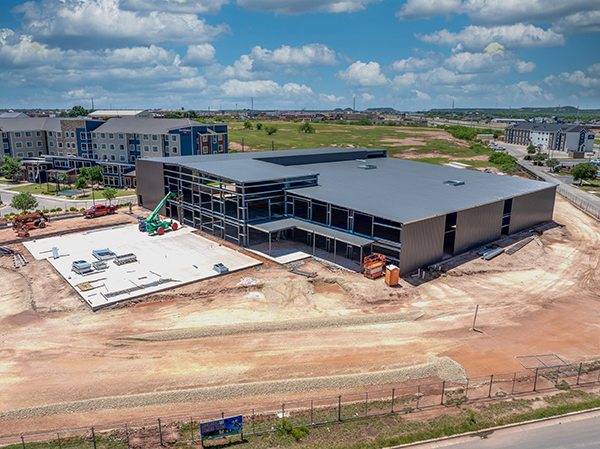
Construction sites are complex, dynamic environments where progress is genuinely difficult to assess from ground level. A drone provides a bird's-eye view that reveals the complete picture , the entire site in a single pass, with documentation that can be compared week over week to precisely track progress against the schedule.
What Drone Monitoring Covers at Each Phase
Pre-Construction
Before ground is broken, aerial documentation establishes the legal baseline: existing site conditions, topography, drainage, vegetation, and neighboring property boundaries. This pre-construction record is invaluable for disputes, environmental compliance, and planning logistics.
Foundation and Structural Phases
- Excavation volume calculations and grade verification
- Foundation alignment and dimensional accuracy checks
- Concrete placement coverage and quality assessment
- Structural progress documentation for owner and lender reporting
Building Construction
- Framing and structural completion tracking
- Roofing installation and material coverage verification
- Exterior work: siding, windows, and finish progress
- Site preparation, landscaping, and paving progress
Final Completion
Comprehensive close-out documentation provides a permanent record of the completed project , useful for warranty claims, insurance, future renovations, and marketing.
Who Benefits and How
Project Managers
Real-time progress data means fewer surprises. Issues are caught weeks earlier, subcontractor progress is objectively documented, and schedule decisions are based on actual data rather than verbal reports.
Property Owners and Investors
Aerial progress reports provide transparency into the investment at every phase. Milestone verification before draw requests, documentation for insurance, and early detection of potential issues protect the owner's interests.
General Contractors
Change order documentation becomes airtight. Safety compliance is verifiable. Client communication is elevated , professional aerial reports set you apart from competitors who deliver only written updates.
Advanced Capabilities: 3D Mapping and Photogrammetry
Beyond standard photography and video, advanced drone services include photogrammetry-generated 3D site models for precise volumetric calculations and orthomosaic maps that integrate directly with CAD and BIM software for detailed site analysis.
Recommended Monitoring Schedule
- Pre-construction: Complete site survey and baseline documentation
- Foundation phase: Weekly flights during excavation and concrete work
- Structural phase: Bi-weekly flights for framing and major installations
- Finishing phase: Monthly flights for exterior and site work
- Final completion: Comprehensive close-out documentation
Cost-Benefit Reality
Drone monitoring typically costs a fraction of traditional surveying methods while delivering far more comprehensive documentation. The bigger savings come from catching problems early , a $500 drone flight that identifies a framing error before drywall goes up can save tens of thousands in rework. Projects that invest in regular aerial documentation consistently report reduced rework, fewer schedule disputes, and faster stakeholder approval processes.
West Texas Construction: Why Aerial Documentation Matters Here
Construction projects in San Angelo and the Concho Valley face environmental conditions that make aerial documentation especially valuable. West Texas wind, dust events, and intense summer heat can accelerate material degradation and affect site conditions between visits. Regular aerial documentation creates a timestamped record that distinguishes normal environmental wear from contractor workmanship issues — important for warranty claims and dispute resolution down the road.
The region's ongoing growth in commercial and industrial construction, driven partly by energy sector activity and population growth in the Permian Basin corridor, has increased demand for rigorous project documentation. Lenders and investors on larger projects increasingly require regular progress reports with aerial documentation before releasing draw funds. Our reports are formatted to meet these requirements and can be delivered on whatever schedule your lender or ownership group specifies.
Integration with Project Management Tools
Aerial imagery and data can be delivered in formats that integrate directly with common construction project management platforms. Orthomosaic maps can be georeferenced and imported into CAD or BIM software for precise measurements and clash detection. Progress photos are organized in date-stamped folder structures compatible with document management systems. For larger projects, we can configure delivery to match your team's specific workflow so aerial data flows directly into your existing reporting process.
Frequently Asked Questions
How far in advance do I need to schedule monitoring flights?
For standard monitoring visits, 48–72 hours' notice is typically sufficient. For pre-construction baseline surveys or milestone documentation tied to specific deadlines, we recommend scheduling at least a week ahead. We work around your project schedule and can often accommodate same-week requests for ongoing monitoring clients.
What weather conditions prevent drone flights in West Texas?
We cannot fly in sustained winds above 25 mph, during active precipitation, or in reduced visibility conditions. West Texas is generally favorable for drone operations — clear skies and low humidity are the norm. When weather causes a delay, we reschedule promptly to minimize any gap in your documentation record. Most delays are resolved within 24–48 hours.
Can drone data serve as legal documentation in construction disputes?
Yes. GPS-timestamped aerial imagery and orthomosaic maps with accurate measurements have been used successfully in construction disputes, insurance claims, lien proceedings, and environmental compliance documentation. The key is establishing a consistent, dated documentation record from project start — which is exactly what a regular monitoring schedule provides. Starting documentation mid-project is better than nothing, but the pre-construction baseline is the most valuable piece.
Do you provide raw files or processed deliverables?
We provide both. Standard deliverables include processed, color-corrected photography organized by date and area, along with a written summary of observed progress. Clients who want raw files for their own archive or processing can receive those as well. Orthomosaic maps and 3D models are delivered in standard GIS and CAD-compatible formats including GeoTIFF, DXF, and OBJ.
What size projects do you typically monitor?
We've covered everything from single-structure residential builds to multi-acre commercial, industrial, and infrastructure projects in the Concho Valley and beyond. There's no minimum project size — even smaller builds benefit from the documented baseline and progress record that aerial documentation provides. Pricing scales with project size and monitoring frequency.
Our Construction Monitoring Services
Concho Valley Aerial Solutions provides FAA-certified construction monitoring for projects across the Concho Valley and West Texas. We offer flexible scheduling to match your project's pace, fast turnaround on reports, and digital delivery of all imagery and data. All operations are fully compliant with FAA Part 107 regulations and covered by commercial aviation insurance.
Keep your project on track
Schedule Construction Monitoring for Your Site
Concho Valley Aerial Solutions , based in San Angelo, serving all of West Texas.
Request a Quote